BLM Fire Management Plan
Royal Gorge Field Office
Canon City, Colorado
September 26, 2001
Fire Management Area Goals:
To guide fire management decision-making in planning and
managing fuels treatments, an interdisciplinary team of resource specialists
from the Royal Gorge Field Office has identified resource and fire management
goals for all of the BLM administered lands in the planning area.
Green - Category A: Fire is not desired
at all.
Yellow - Category B: Wildfire is not desired.
Orange - Category C: Fire is desired; social, polictical or ecological constraints.
Red - Category D: Fire is desired; few to
no constraints to its use.
The Fire Category Map was created by identifying management
concerns or issues that required specific resource protections or constraints
or presented fire management opportunities. These issues were:
-
Wildland/urban interface and the effects of Federal
decisions on private lands.
-
Wilderness Study Areas (WSA's), management restrictions
and potential for contain/confine strategies rather than control strategies.
-
Wildlife critical winter/birthing habitat and impact
from fire.
-
Developed facilities authorized on public lands and
protection of valid, existing rights.
-
Noxious weeds, control, seedbed preparation and seed
transport.
-
High value forest areas and protection of timber
investment.
-
Riparian areas and effects of rapid surface water
runoff.
-
Grazing allotments and effects of a large fire upon
a permittee.
-
Smoke and impacts upon people and the environment.
-
Visual effects of fire and scarring upon the environment.
-
Effects of fire on cultural and historical resources.
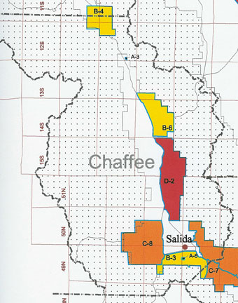
Category C
Polygons: Fire is desirable, but limitations exist.

The yellow shaded areas are BLM property and are part of the Poncha West polygon. Green indicates San Isabel
National Forest. White is privately owned land.
Polygon
Name: Poncha
West, (C-8)
Vegetation
& Desired Condition: Dominant
Vegetation consists of a mix of pinyon-juniper woodland, conifer and aspen.Grassy
parks are common. Desired condition is to maintain the current vegetative
condition.
Resource
Management Objective: Re-introduce
fire to the ecosystem where it does not present an unacceptable risk to
firefighter/public safety and private lands. Manage wildfire to maintain
the current vegetative mix. Utilize prescribed fire and mechanical treatments
to mitigate fuel loadings in areas where unacceptable risk exists.
Resource
Constraints: Manage
85% of wildfires to an individual size of less than 100 acres. Limit total
burned acres to 1,000 acres annually.
Suppression
Constraints: No
use of aerial retardants within 300 feet of perennial streams.
Resource
Vegetation Treatments: None
completed. No additional work planned currently.
Hazard
Fuels Treatments:
None completed. No additional work planned currently.
Suppression
/ Pre-suppression: None
Monitoring:
Fire occurence, both planned and natural, as well as other vegetative
treatments will be evaluated each year following the fire season and/or
hazardous fuels treatments to ensure that resource management objectives
and constraints have been met or to re-evaluate those objectives and constraints
for modification. The completed hazard fuel treatments will be reviewed
annually and changes in polygon classification considered based on the
review results.
|
|
|
Fire Categories:
Category A: All fire (wild or prescribed) is undesirable.
All wildfires will be suppressed. Prescribed fires will not be considered
for fuel treatment projects although other options might be considered.
The polygons included in this category include locations where fire
is not believed to be a part of ecosystem function or where suppression
is considered essential to prevent direct threats to life or property.
Category B: Wildfire is not desired. These polygons
include locations where an unplanned ignition could have negative
effects without mitigation. Wildfire in these polygons would be
aggressively suppressed. Negative effects include risk to private
lands and urban interfaces, important cultural resources, areas
with fuel loads that would be unmanageable under wildfire conditions
and areas where a natural seed bank might not exist for reseeding.
Mitigation efforts would include fuel reduction through mechanical
means or prescribed fire to reduce fuel loadings to levels manageable
under wildfire conditions, creation of agreements to allow fire
to cross from public to private lands, cultural resource inventories
and preparation, in advance, of rehabilitation plans for wildfires.
Category B polygons are prime locations for hazard reduction projects
to mitigate existing hazards. An example would be creating a fire
break around a developed recreation site. Once mitigations were
complete, these locations could be moved into a category where wildfire
might be considered desirable.
Category C: Fire (wild and prescribed) is desirable
but its use is complicated by social, political or ecological constraints
that must be considered. These constraints could include air quality
considerations (proximity to Class I airsheds), threatened or endangered
species (effects of fire on the survival of a listed species) or
habitat considerations. Habitat considerations could be described
in terms of maximum burn acreage (ie. no more than 10% of an area
in a single year) to ensure sufficient habitat for the remainder
of the year or to prevent undue hardship on a grazing permittee
as a result of a managed wildfire. Prescribed fire and other treatment
options might be used in these areas to help attain desired resource
or ecological conditions.
Category D: Fire (wild and prescribed) is desirable
and there are few if any constraints to its use. These polygons
offer the greatest opportunity to take advantage of a full range
of options available to the resource manager for managing fire in
the environment.
|
|
