California
Department of Forestry and Fire Protection
Review Report of Serious CDF Injuries, Illnesses, Accidents
and Near-Miss Incidents
Engine Crew Entrapment, Fatality, and Burn Injuries
October 29, 2003
Cedar Fire
CACNF-003056
CACSR-000132
Southern Region
SITE CONDITIONS
Topography and Fuels
The hillside west of the accident site has west-facing slopes ranging
from 20-40 percent. The uniform fuel complex is was dominated by a well-developed
herbaceous brush mix with 90 percent crown closure, under a live oak canopy
that averaged approximately 20 feet tall and ranged from 30-90 % cover.
The live fuel components were well below critical levels (what was %).
The dead component is estimated as light to moderate, approximately 30
percent.
Fire history for the area was not complete and it is estimated the last
fire through the area was 50 to 60 years ago.
During the 36 months previous to the accident the area has only received
between 50-70 percent of normal precipitation. The Palmer Drought Index
shows a preliminary drought (index of – 2.88) with 2.07 inches of
precipitation necessary to emerge out of the drought condition.
The relative orientation of the San Diego river drainage below the accident
site is NNE to SSW. The elevation where the drainage crosses Highway 78/79
is approximately 3,440 feet. The elevation at the head of the canyon is
4,136 feet and the elevation at the accident site is 3,822 feet.
The ridge along the west side of the San Diego River drainage ranges
from 3,723 feet to 3,678 feet. Directly west of the accident site there
is a saddle that drops to approximately 3,600 feet.
The accident site is on a high point along the ridge with a chimney/saddle
immediately to the south (between 920 and 930) and immediately to the
north (between 920 and the 914 site). The garage and 90-degree turn in
the driveway are in the northern saddle.
Improvements and Building Condition
The accident site house at 920 Orchard Lane was a one-story 2,045 square
foot single-family dwelling built in 1977. It was located on a four-acre
parcel on the top of the ridge, 300 feet west of, and 69 feet above, Orchard
Lane. The layout of the house was basically a rectangle 23 feet wide and
78 feet long, with the long dimension oriented approximately parallel
to the ridgeline. The northern end of the long dimension was oriented
towards the north-northeast (referred to as north for reference and discussion).
The north end of the house included a 31-foot diameter hexagonal area
with a stone chimney in the center, which is the prominent feature visible
in post-fire photographs. The concrete driveway from Orchard Lane ends
at the north end of the house. The unimproved dirt surface driving or
parking area, which varies in width from 15 feet to 35 feet, extends for
a total of 150 feet south from the end of the driveway along the entire
west side of the house and extending 75** feet south of the house along
the patio and flower garden (** measurements “from the house”
refer to distances measured from the exterior wall of the house).
The exterior house construction consisted of stucco walls and a combination
of roof coverings consisting of composition shingle and flat rolled roof
covering.
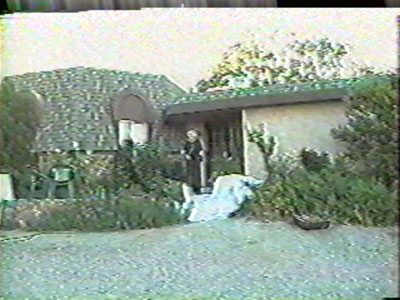
Photo from the 2001
Lis family video of 920 Orchard showing the combination roof covering
style, the house front door, the unimproved dirt surface driving area,
and the landscape vegetation as it existed in 2001*
* NOTE:
All photos from the “Lis family video” are still images
captured from the original VHS video. The approximate date of filming
was June 2001. Any changes in conditions, such as reduction in the
amount of vegetation, during the three years between the video filming
and the fire are not reflected in the photos.
A wooden deck, approximately one to three feet above the ground, extended
for 19 feet to the north and northeast off two sides of the octagonal
portion of the house. On the east side of the house, a wooden deck walkway
extended south of the main deck area between the house and large boulders
to the rear door.
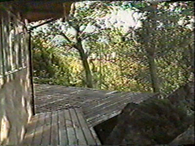
Photo from the 2001 Lis family video showing the east side of the house
looking northeast at the eastern portion of the main wooden deck from
the wooden walkway. The northern end of the large boulders is shown
on the right side.
From the rear door, the walkway continued south 48 feet as a concrete
path, connecting the rear door to a 14 by 28 foot concrete patio on the
south end of the house. The patio was surrounded on the south and west
sides by a planter strip with a continuous juniper hedge (see description
below) and a rock wall two to three feet above grade level. A flower garden
approximately 30 by 40 feet in size extends south of the patio and rock
wall. Concrete and stone steps on the west side of the patio lead down
to the dirt parking area where Engine 6162 was parked, two to three feet
below the level of the patio.
A detached garage was located 80 feet north-northwest of the house on
the west side of the driveway. It was a 25-foot by 25-foot wood-frame
stucco structure with doors facing north.
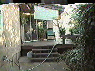
Photo from the 2001 Lis family video showing the east side of the house
looking northeast at the wooden walkway to the deck and the northern
end of the concrete walkway. The back door is to the left at the top
of the stairs. The kitchen is through the sliding glass doors.
Brush Clearance
The vegetation fueling the wildfire, which burned in the immediate vicinity
of 920 Orchard Lane, may be characterized in two groups – managed
landscape plantings (described below) and relatively unmanaged brush and
oak wildland fuels. The heavy brush and oak wildland fuel bed is fully
described in the Fire Reconstruction…Executive Summary
(Tab Section 251) and the Fire Reconstruction...full report (Tab
Section 252). Extensive clearance of this wildland brush existed in all
directions around the house. Downhill, in the direction of the fire approach
to the west, the wildland brush began approximately160 feet below the
northwest corner of the house. There was 180 feet of brush clearance downhill
from the southwest corner of the house where Engine 6162 was located.
There was no evidence of recent brush clearance activity, such as cut
brush stumps, in the large cleared area below the house. Fuels in this
area, which measured approximately 170 feet deep and 200 feet along the
driveway, consisted of light grass stubble closer to the brush and oak
leaf litter or cleared ground closer to the house.
Photo from the 2001
Lis family video looking southwest from the dirt driveway at the southern
end of the large brush clearance area below the house. The image is
recorded from the general area of where Engine 6162 was parked.
To the south of the house the brush clearance extended approximately
100 feet, or approximately 40 feet behind Engine 6162. There was approximately
70 feet of brush clearance east of the house, which was the leeward side
of the house during the entrapment. Due east from the northern end of
the house, beginning approximately 30 feet east of the house deck, a large
unburned island of oaks extends along the south side of the driveway down
to Orchard lane, an area approximately 280 feet long by 50 feet wide (see
Figure 4). There was no consumption of the oak tree canopy in this area
and only partial burning of the surface fuels. In this area closest to
the house, the unburned surface fuels consisted of oak leaf litter. The
grass, if any, had been cleared and there were no ladder fuels below the
tree canopies. To the north of the house the brush fuel bed began along
the north side of the driveway, 115 feet north of the house.
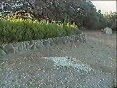
Photo from the 2001 Lis family video looking southeast from the dirt
driveway. Brush clearance to the south of the house just visible to
the right of the large boulder. The box hedge and rock wall next to
where Engine 6162 was parked is in the center of the image.
Landscape vegetation
There was extensive management of the vegetation and grounds for approximately
70 to 180 feet around 920 Orchard Lane. The most prominent feature of
this landscaped area was the large cleared area west of the house in the
direction of fire approach. This area can be easily seen in Figure 9,
the pre-burn accident site aerial photograph taken in July 2000. Forty-five
feet west of the house front door was an herbaceous hedge bordering the
driveway with a rock path leading down several steps to a relatively flat
garden area approximately 30 deep and 50 feet long parallel to the driveway.
This garden was at the northeastern end of large cleared area and contained
well-separated herbaceous plantings, small woody shrubs and a few small
fruit trees. On the west side of the house on either side of the front
door were several two to four foot tall shrubs. South of the front door
were two large shrubs reaching to the roofline (visible in Lis family
video photo of the front door above), and a 20 to 30 foot tall oak tree
towards the southwest corner of the house.
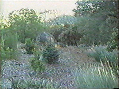
Photo from the 2001 Lis family video looking northwest at the garden
west of the front door. The image is recorded from the rock path / steps
(shown in Figure 2) leading through the herbaceous hedge.
The patio on the south end of the house was surrounded on the west, south,
and east sides by a juniper hedge. The linear burn pattern along the south
edge of the patio concrete appears to indicate that the juniper hedge
was continuous, and encroached approximately one foot over the southern
patio surface. It also extended around both southwest and southeast corners
of the patio and on both sides of the steps to the driveway. The perimeter
of the hedge, as estimated from patio burn patterns, is shown on Figure
2 and Figure 4. The extent of recent pruning of the Juniper hedge is unknown
and the height of the hedge is not estimated. A tall cylindrical shaped
Juniper-like coniferous shrub was planted in each of the “tree well”
planting boxes shown at the two corners of the patio in Figure 4. The
canopy of a 16-inch diameter oak tree covers the entire patio as shown
in aerial photograph Figure 8.
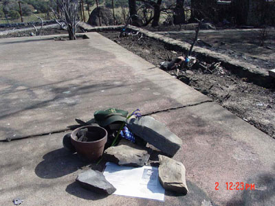
Photo of the accident
site patio at the south end of the 920 Orchard Lane house. Juniper hedge
stumps can be seen between the southern edge of the patio and the rock
wall on the right, and in the triangular planting area adjoining the
eastern end of the patio. One of the two shrub stumps located in the
“tree wells” (shown in Figure 4) can be seen at the top
of the photo. The concrete patio burn pattern, indicating the presence
of a continuous Juniper hedge encroaching over the patio, is shown along
the right edge of the patio* . The concrete patio burn spall marks indicated
in Figures 4 & 5 can been seen around the memorial items in the
center of the picture (photo reference - Foote item #51 Tab Section
122).
* For
additional Juniper hedge burn pattern images see: Tab Section 108 photo
item number 25; Tab Section 110 photo item numbers 24, 53 & 59;
and Tab Section 115 photo item number 66.
Along the east side at the rear of the house most of the landscaping
had been recently removed leaving two grape vines and some wisteria all
of which had lost it’s foliage by the time of the fire. A large
rock outcropping adjacent to the house, approximately 20 feet in diameter
and six to10 feet in height, extended from the area of the back door to
the southeast end of the wooden deck.
A row of approximately five-inch diameter shrubs lines what would have
been the northern edge of the wooden deck (see white steno pad in photo
#12:20). With the wooden deck extending past the cinder blocks, this hedge
would have created a continuous fuel bed from the landscape vegetation
to the readily ignitable structural materials of the house deck. The landscaped
area in the 110 feet north of the house to the driveway was denser than
elsewhere on the property. Another row of burned out shrubs lines the
southern edge of the driveway directly north of the house. The June 2001
video photograph of the driveway shows continuous surface fuels to the
right of the driveway looking north, although some of this could have
been pruned in the intervening years. There is 90+% closure of the conifer
and oak tree canopy over this area. There are also rock retaining walls,
paved walking paths, and patio areas throughout the area with patches
of unburned surface fuels.
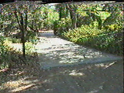
Photo from the 2001
Lis family video looking north at the driveway. Continuous, heavy, landscaped
surface fuels can be seen on the right side of the driveway above and
in the post fire photo (Tab Section 108 photo item #41) of the same
area.
Equipment
Engine 6162, is a series 2000 International similar to a CDF model 14.
Engine 6162 outfitted with a four person cab, 500 gallon tank and 500
GPM pump, is nine feet eight inches wide, 24 feet long, and nine feet
four inches tall, with a wheel base of 160 inches. It has a documented
mileage of 10230.6 corresponding to 897.9 engine hours. These figures
were recorded once the engine was returned to the Novato Fire District
from the Cedar incident. The truck log book as of October 26, 2003 indicates
a mileage of “9558.” There are no recorded figures for the
subsequent days of the incident
Road Conditions
Orchard Road leads directly from Highway 78/79 and proceeds in a generally
straight path toward the north. Orchard Road is the access route that
leads directly to the driveway of the accident site (920 Orchard) and
terminates at the driveway of 902 Orchard Road at its northernmost point.
The road has a small turnout opposite and just south of the driveway of
the accident location. From the intersection of Highway 78 to the driveway
of the accident location, it measures 0.8 miles. The distance to its endpoint
at 902 Orchard is 0.9 miles. The road varies in width from approximately
nine feet to 14 feet. It is unimproved other than gravel over compacted
dirt.
The driveway to 920 Orchard forms an approximate 43 degree angle with
the main road and proceeds initially in a northwest direction. The 490
foot concrete driveway continues upslope where it terminates near the
northwest corner of the residence along the ridgeline. The overall slope
from beginning to end of the concrete section is 16 percent with the steepest
point being approximately 20 percent. The driveway is nine feet wide and
is lined with brush and trees on both sides.
As it continues upslope, at the 60 foot mark the driveway makes a turnout
to the north and proceeds back in a westerly direction to the 110 foot
mark. This turnout coincides with the steepest slope of the run. This
deviation combined with a culvert that exits to the north edge of the
concrete drive in this turnout makes traversing this portion with an engine
a slow and calculated process. At the top of the ridgeline, the driveway
forms a sharp right angle where it finally terminates near the northwest
corner of the house. At the final portion of the curve, a short section
exits and proceeds to the detached garage.
At the end of the concrete section, the driveway continues along the
ridgeline and proceeds along the west face of the house. This section
of the driveway is an unimproved dirt surface and proceeds 150 feet in
a south-southwest direction before it terminates just past the concrete
patio.
Two driveways lead to 902 Orchard Road (to the north on Orchard Road
from 920 Orchard) and ultimately join along the ridgeline. The overall
effect of the driveway is to circumferentially wrap the property. It is
a primarily dirt surface. There is little vegetation to either of its
immediate edges.
The driveway to 930 Orchard Road (the next residence south of 920 Orchard
Road) proceeds upslope to the residence and ridgeline. It is entirely
surfaced in blacktop and is lined on both sides by dense brush. The brush
is sufficiently thick that it encroaches upon the driveway.
<<< continue
reading—Graphics - List of Illustrations Table>>>
|