
Lessons Learned
“Safety
Zone” newsletter, July, 2004
Lessons Learned —
author, date unknown
One-Year Anniversary Letter
by Kelly Close, FBAN
Declaration on Cramer
Redactions, by James Furnish, April, 2005
FSEEE v. USFS, FOIA
Civil Lawsuit Order,
December, 2005
FOIA
Request to USFS, December, 2005
FOIA Appeal to USFS,
February, 2006
Management Evaluation Report
Investigation Team Information
Synopsis of the
Cramer Fire Accident Investigation
Causal Factors
Contributing Factors
Addendum
Factual Report
Executive Summary
Narrative
Background
(facts 1 - 57)
Preaccident
(facts 58 - 201)
Accident
(fact 202)
Postaccident
(facts 203 - 237)
Findings
Appendix A
Resources on the Fire
Appendix B
Cramer Fire Timeline
Appendix C
Fire Behavior and Weather
Prior Conditions
Initial Phase
Transition
Phase
Acceleration
Phase
Entrapment
Phase
Appendix D
Equipment Found at H-2 and the Fatalities Site
Appendix E
Fire Policy, Directives, and Guides
OIG Investigation
OIG FOIA Response,
February, 2005
2nd FOIA Request to OIG,
April, 2006
2nd OIG FOIA Response,
August, 2006, (1.4 mb, Adobe .pdf file)
OSHA Investigation
OSHA Cramer Fire Briefing Paper
• Summary and ToC
• Sections I-IV
• Sections V-VII
• Section VIII
• Acronyms/Glossary
OSHA South Canyon Fire
Briefing Paper
Letter to District
Ranger, June 19, 2003
OSHA Investigation Guidelines
OSHA News Release
• OSHA Citation 1
• OSHA Citation
2
• OSHA
Citation 3
USFS Response
OSHA FOIA Letter
Adobe PDF and Microsoft Word versions of documents related to
the Cramer Fire can be downloaded from the U.S.
Forest Service website.
|
Accident Investigation
Factual Report
Cramer Fire Fatalities
North Fork Ranger District
Salmon-Challis National Forest
Region 4
Salmon, Idaho - July 22, 2003
Appendix C—Fire Behavior and Weather
Fire Behavior, Initial Phase: July 19 (2100)
through July 22 (1015)
July 19
Lightning was reported in the Cramer Creek area at about 2100. A single-tree
strike ignited what was to become the Cramer Fire on a spur ridge running
south of the West Ridge. The fire was not detected until the following
afternoon.
July 20
The Cramer Fire was reported at 1630 by Long Tom Lookout. It was burning
on the upper portion of a steep, rocky westfacing slope. A smokejumper
plane (jumper 41) diverted to the Cramer Fire estimated it to be about
3 acres (figure 15) with high spread potential. The fire was burning primarily
in grass and light ponderosa pine needle litter (fuel models 1 and 2).
Fuels were sparse and light, and the fire was spreading by creeping, backing,
and rolling burning material (rollouts). By the end of the day, it had
burned up to the top of the spur ridge (figure 16) and was spreading downhill
by backing and rollouts.
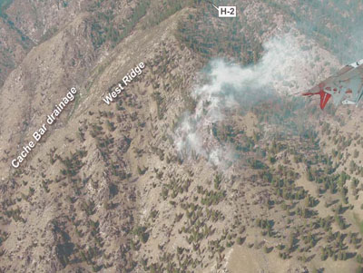
Figure 15—Cramer
Fire from jumper 41 plane, July 20, 2003, at 1705.
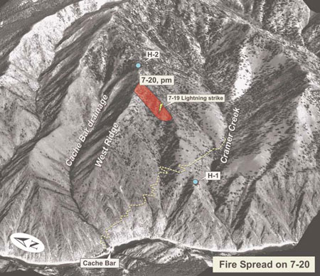
Figure 16—Cramer
Fire perimeter and spread on July 20 later in the evening.
At 1938, the fire was 20 to 25 acres. It was burning through grass and
sagebrush on the lower portion of the fire, and in open timber in the
upper portion. In the timber stands, the fire was reported to be burning
actively but spreading slowly. A thermal belt had set up late in the evening
in the area, and conditions on the fire remained warm and dry. The fire
remained active through late night and early morning. At 0130, the temperature
on the fire was 73 °F with little humidity recovery. Rollouts were frequent,
and included large trees which were reported rolling from the top to the
bottom of the slope. The fire began to die down about 0230 with increasing
RH.
July 21
Relative humidity recovery overnight was 63 and 66 percent at Indianola
and Lodgepole RAWS, respectively. Fire activity was minimal in the morning,
with only minor fire growth after 0300. At 1000, air attack estimated
the fire size to be 40 acres. There was some fire activity on the northeast
corner, but the western perimeter had burned into rocks and appeared cold.
A spot weather forecast was requested at 0710 and received on the fire
at 0800. At 0800, fire personnel noted that winds the previous night were
much stronger than they had expected, and the spot forecast for July 21
(figure 17) called for winds much lower than they were expecting.
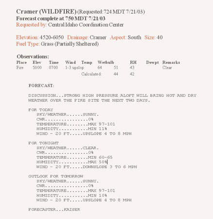
Figure 17—Spot
weather forecast issued by the NWS Pocatello office for July 21.
After 0900, the RH began to drop steadily. Fire activity began to pick
up by 1130, with RH values dropping into the low 20s at midelevations
and into the teens at lower elevations. Most of the fire activity was
on the north and east sides, and picked up through the afternoon with
increasing, shifting winds. Gusts 15 to 20 mph were reported on the fire.
The fire was moving to the south and west and backing east down into the
main Cramer Creek drainage. By 1715, air attack estimated the fire to
be about 60 acres. RAWS observations indicate this time was nearing the
peak of the burn period. In the next 21/2 hours, the fire burned actively
with surface fire spread and rollouts, and isolated torching, and grew
an additional 140 acres.
At 1830, the fire spread into the Cache Bar drainage. A retardant drop
from the previous day, running approximately 100 yards down the West Ridge
(toward the west), stopped the fire spread to the north of the West Ridge
into the Cache Bar drainage. However, on July 21st, as the fire spread
laterally westward below the West Ridge, it burned west of the end of
the retardant drop. A small portion of the perimeter then burned over
the West Ridge to the north, into the Cache Bar drainage immediately below
the West Ridge. Fire activity was moderate in light fuels, and this slopover
was evidenced by light smoke seen in the early evening during a recon
flight over the area (figures 20 and 21).
At 1952, air attack estimated the fire to be 200 acres (figure 18).
After 2000, the fire intensity to the east and northeast began diminishing,
and the west side of the fire was reported to have appeared relatively
quiet.
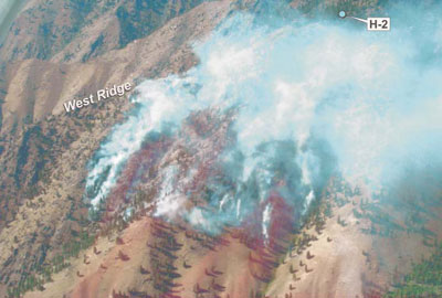
Figure 18—Cramer
Fire late afternoon on July 21, showing typical fire activity for that
day.
Through the late night and early morning, the fire was again under the
influence of a midslope thermal belt. The fire continued to spread by
backing (figure 19), rollouts, and short uphill runs. Fire behavior was
limited to low- and moderate-intensity surface fire burning through grass
and understory litter in open stands of ponderosa pine and Douglas-fir.
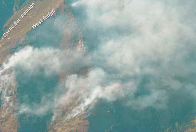
Figure 19—Cramer
Fire early evening on July 21, showing backing and short surface fire
runs.
On July 22, the fire continued to burn actively until about 0300, when
increasing RH caused fire activity to slow substantially. After 0300,
the valley inversion in the Salmon River drainage strengthened, and the
entire fire area was under the inversion which was at 6500 feet. Fire
activity after 0300 consisted of backing and creeping through grass, with
scattered smokes in open timber. On the east side, fire intensity was
low with flame lengths less than one foot in grass and open pine. There
was some fire below H-2 to the east, but it was not very active. The inversion
did not begin to break until about 1015.
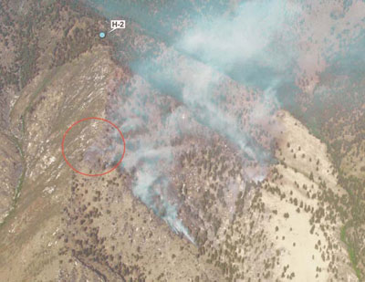
Figure 20—Movement
of the fire into the Cache Bar drainage late in the day on July 21.
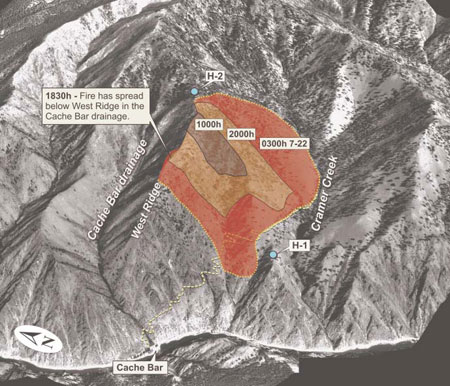
Figure 21—Cramer
Fire perimeter and spread on July 21, 2003, and early morning on July
22.
No spot forecast was requested for July 22, but the fire
weather forecast (zone 405) was discussed at the 0900 morning briefing.
During this briefing, fire personnel were informed that conditions had
been getting progressively warmer and drier the last few days. Crews on
the forest often rely on persistence probability for fire behavior forecasting
in the area, using the zone fire weather forecast and the previous days’
weather and fire behavior to predict conditions for the current day.
Table 2 shows a comparison of zone fire weather forecast conditions
forecast for the afternoon to RAWS observations.
Table
2—Zone fire weather forecast comparisons.
| Source |
temperature (°F) |
RH (percent) |
(mph) |
| Forecast |
86 to 95 (valley)
81 to 87 (ridges) |
9 to 17 |
NW 5 to 15 |
| Long Tom Lookout |
81 to 85 |
18 to 20 |
N 2 |
| Lodgepole |
91 to 96 |
8 to 11 |
WNW 6 to 14 |
Indianola |
98 to 106 |
8 to 12 |
ESE 1 to 9
(1300 to 1600) |
<<<
continue reading Appendix C, Transition Phase >>>
|